United Nations votes to adopt new world map to reflect Africa’s true size. USA is the only country to vote against the resolution, calling the initiative as unnecessary and ideologically motivated
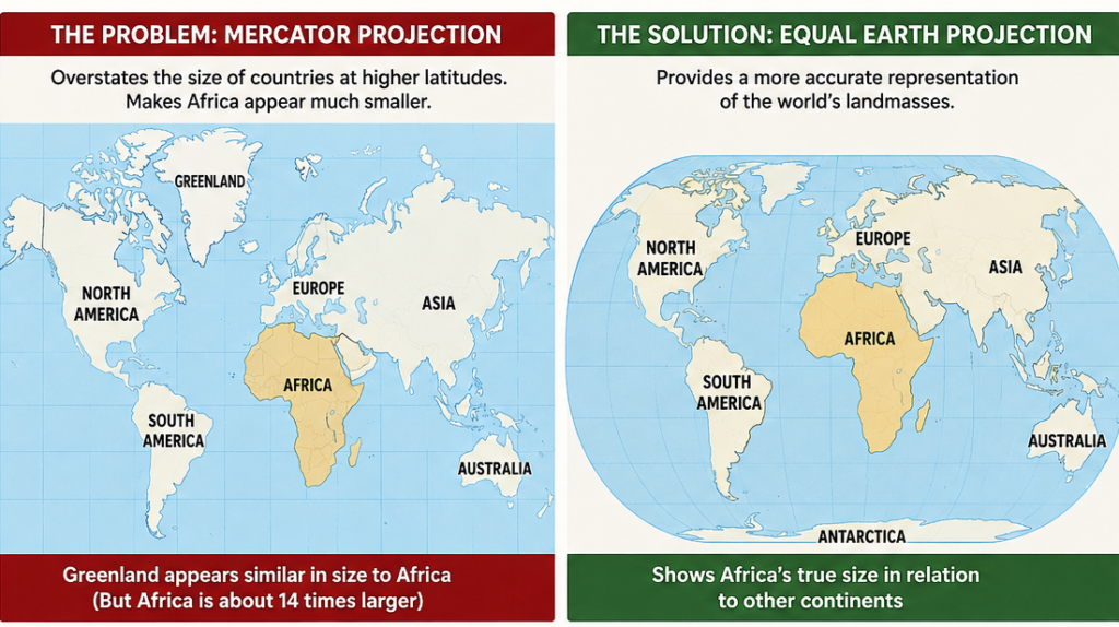
The United Nations General Assembly has overwhelmingly backed a Togo-led initiative to promote a new world map that more accurately represents the size of Africa and other continents, marking a significant symbolic victory for an African campaign challenging centuries of distorted geographical representation.
The resolution promoting the Equal Earth projection was adopted with 164 countries voting in favour, six abstentions and only the United States voting against. The initiative was spearheaded by Togo and supported by the African Union’s 55 member states.
The move seeks to reduce reliance on the Mercator projection, developed by Flemish cartographer Gerardus Mercator in 1569. While the projection remains useful for maritime navigation, it significantly exaggerates the size of landmasses closer to the poles and makes regions around the equator appear disproportionately smaller.
One of the most striking examples is Greenland, which appears comparable in size to Africa on many Mercator maps, despite Africa being about 14 times larger. The Equal Earth projection, developed in 2018, provides a more accurate representation of the relative areas of the world’s continents.
Togo leads Africa’s cartographic campaign
The resolution is the culmination of Togo’s #CorrectTheMap campaign, which was endorsed by the African Union in 2025. Togo’s Foreign Minister Robert Dussey framed the initiative as an effort to change how Africa is perceived globally.
The campaign argues that maps are not merely geographical tools but also shape perceptions of the relative importance and scale of countries and regions. Advocates say the widespread use of distorted maps has contributed to an underestimation of Africa’s physical, demographic and geopolitical significance.
The UN resolution is not legally binding, meaning countries and institutions are not required to abandon the Mercator projection. However, it encourages governments, international organisations, educational institutions and technology companies to promote more accurate alternatives. Togo is reportedly planning discussions with UNESCO, the African Union and mapping companies on implementation.
More than a change in cartography
The vote gives the campaign significance beyond geography. For African governments and advocates, correcting the map is part of a wider effort to challenge inherited narratives about the continent and assert greater agency in how Africa is represented.
The outcome also comes amid growing calls for reforms in global institutions and greater recognition of Africa’s economic, demographic and geopolitical weight. The overwhelming UN vote gives Togo and the African Union a diplomatic platform to take the campaign into schools, textbooks, media, digital mapping platforms and public institutions.
The United States, the only country to vote against the resolution, described the initiative as unnecessary and ideologically motivated. Nevertheless, the overwhelming vote in favour signals broad international support for a more geographically accurate representation of the world’s continents.
For Africa, the significance may ultimately lie less in replacing one map with another than in changing the narrative around the continent. As Togo’s campaign argues, a more accurate map cannot change Africa’s size—but it can change how the world sees it.